
Spatial planning approaches of cities
-
Aarhus has developed a highly structured catchment-based approach to stormwater management, integrating spatial planning, utility investments, urban development, and nature-based solutions. The approach is based on the principle that stormwater challenges should be addressed at the catchment scale rather than through isolated site-level interventions.
A key feature is the institutionalized collaboration between the municipality and the water utility, supported by formal coordination procedures that align planning, financing, implementation, and maintenance. This ensures that stormwater management is integrated into broader urban development processes.
Planning is supported by hydraulic modelling, flood risk assessments, and analysis of historical waterways and natural drainage patterns. These datasets are integrated into the municipal GIS system, providing a shared evidence base for planners, utilities, and decision-makers.
Catchment assessments consider both stormwater challenges and opportunities for implementation, including the availability of public and private land for nature-based solutions. Dedicated teams of planners, stormwater specialists, hydrologists, and utility representatives work together to translate catchment objectives into planning requirements.
Aarhus operates a two-level planning system. At the catchment scale, RVD (Rainwater Management) plans identify flood risks, intervention opportunities, and strategic objectives. At the development scale, RVH (Rainwater Handling) plans translate these objectives into site-specific solutions and design requirements.
Developers are expected to contribute to catchment-level stormwater objectives rather than managing runoff solely within project boundaries. A commonly applied guideline is to provide at least 2 m³ of stormwater detention volume per 100 m² of developed area to help reduce downstream flood risks.
Through this integrated framework, Aarhus has established catchments as the primary unit for planning and investment decisions, creating a coordinated approach that links flood risk management, urban development, utility planning, and nature-based solutions.
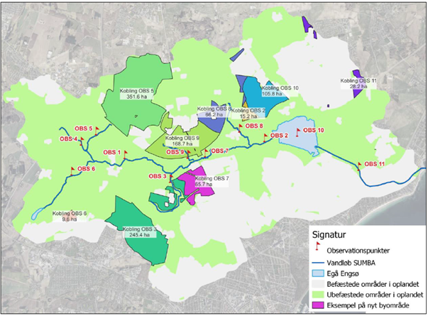
An example of a catchment planning around a river in Aarhus.
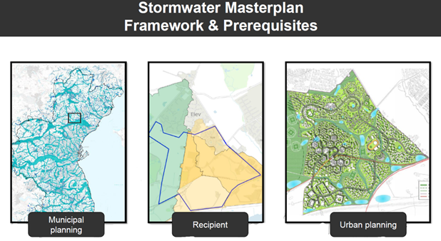
An example of city planning on catchment level.
-
Tampere has developed a catchment-based planning approach that integrates stormwater management into urban planning, climate adaptation, and infrastructure development. By addressing stormwater at the catchment scale, the city manages flood risks, controls runoff, and coordinates urban development more effectively.
The approach is supported by city-wide hydraulic modelling and catchment-level risk assessments, which identify flood-prone areas, evaluate development impacts, and help prioritize stormwater interventions. As part of its Stormwater Strategy, Tampere applied the StormTac methodology to assess flood risks, pollutant loads, and pressures on receiving water bodies across urban catchments.
Implementation depends on identifying suitable locations for nature-based solutions (NBS), with public land availability and cooperation with developers and landowners playing important roles. Coordination is supported by a municipal stormwater management team that brings together expertise from planning, climate adaptation, utilities, and stormwater management. Technical analyses and catchment plans are often prepared by consultants under municipal supervision.
The main outputs of the planning process are catchment-based runoff criteria and future flood routes. Rather than prescribing specific measures, the city sets performance targets that developments must meet, ensuring that individual projects contribute to wider catchment objectives.
Although less formalized than Aarhus’ two-level catchment planning system, Tampere has successfully embedded catchment thinking into strategic planning and development guidance, creating a framework that aligns flood risk management, climate adaptation, and urban development.